What Happened When Odysseus Rounded Cape Malea?
After leaving Ismarus, Odysseus sets sail for home again. The fleet reaches Cape Malea, where the waves, currents and north wind drive the ships off course, away from Cythera. For nine days they are carried across the sea by ruinous winds; on the tenth day, they reach the land of the Lotus-eaters (Odyssey 9.67–84).
Cape Malea matters because it is a place we can still identify on a map. Beyond it, the poem preserves the sequence of Odysseus’ adventures, but no longer provides enough geographical detail to trace a continuous route across the Mediterranean.
Homeward from Ismarus
Sección titulada «Homeward from Ismarus»The fleet leaves Ismarus after losing six companions from each ship. Zeus then sends Boreas, the north wind, bringing a storm that sweeps across sea and land. The wind tears the sails; the men take them down and row hard for shore, where they spend two days and nights, exhausted and grieving (Odyssey 9.67–76).
At dawn on the third day, they raise their masts and hoist their sails once more. Odysseus recalls this as a moment when his return seemed within reach: he might have reached home safely had the wind, waves and currents not driven him off course as he rounded Cape Malea. The episode is neither a continuation of the fighting at Ismarus nor the beginning of an adventure in a strange land. It shows how a voyage that seemed to be leading home is suddenly diverted once again.
Cape Malea and Cythera
Sección titulada «Cape Malea and Cythera»Homer calls the cape Μάλεια (Máleia). It is Cape Malea, at the south-eastern tip of the Peloponnese, in Laconia. The poem also mentions Cythera (modern Kythira), the island to the south-west of the cape. Malea was a crucial landmark on the voyage home from the Aegean: after rounding it, the ships could have continued westwards, rounded the southern Peloponnese and eventually headed towards Ithaca. The way home seemed open, although a considerable voyage still lay ahead.
Homer, however, does not tell us how far the fleet had travelled, on which side of Cythera it passed, or precisely where this stage of the voyage began. What matters in the poem is not how far Odysseus still had to go, but that his return seemed possible until the winds drove him off course.
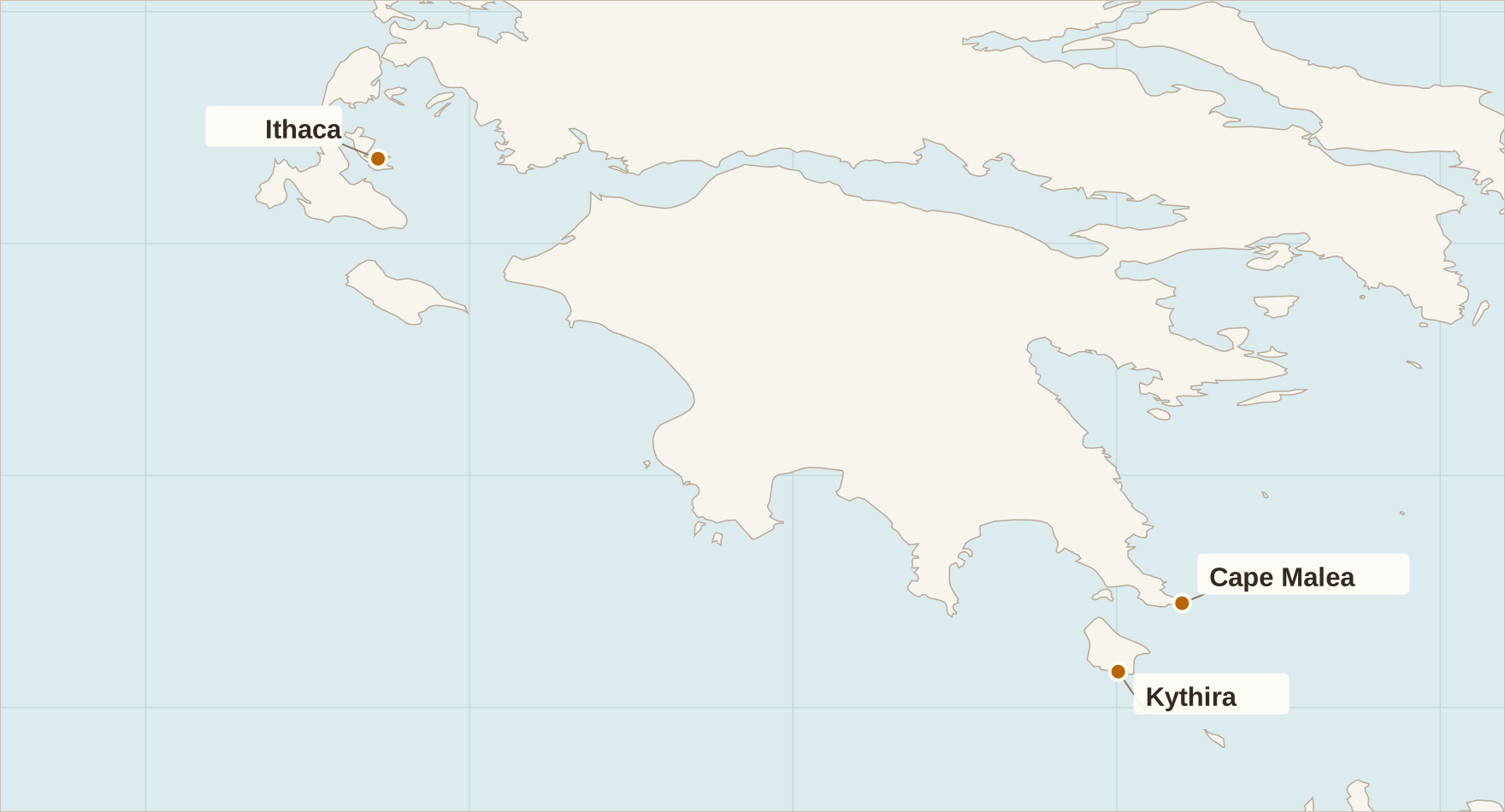
Cape Malea, Kythira (Cythera) and Ithaca. Cape Malea and Kythira lie at the south-eastern edge of the Peloponnese, while Ithaca lies farther west, in the Ionian Sea. Cartography: The World of the Odyssey. Base map: Natural Earth (public domain).
Boreas, Waves and Current
Sección titulada «Boreas, Waves and Current»Odysseus says that, as he rounded Cape Malea, the waves, the current and Boreas drove him off course near Cythera (Odyssey 9.79–81). The Greek does not describe a harbour, a precise course or a passage around the island: it tells us only that he was driven off course in relation to that geographical landmark. We do not know exactly how the ships passed Cythera, how far they travelled or what direction they took.
From that point, Odysseus says he was carried across the sea for nine days by ruinous winds, reaching the land of the Lotus-eaters on the tenth (Odyssey 9.82–84). Homer tells us how long the voyage lasted, but not in which direction the fleet travelled. Those nine days cannot tell us how far the ships went or where precisely they arrived.
The information needed for such a calculation is missing: a consistent heading, the ships’ speed, the changing winds, their manoeuvres, any possible stops and a clearly identifiable destination. Even the use of the plural “winds” cautions against imagining a single, steady wind throughout the voyage. Placing the arrival at Djerba, on the Tunisian coast or at any other modern location requires information the poem does not provide.
The Last Recognisable Point
Sección titulada «The Last Recognisable Point»Malea matters precisely because it is one of the last places we can identify with reasonable confidence on a map before the narrative moves into episodes set in places whose locations are uncertain. What follows is a clear sequence of adventures — the Lotus-eaters, the Cyclopes, Aeolus and the others — but not a reliable chain of geographical locations. The Lotus-eaters certainly come after Malea in the story. Their location, however, cannot be deduced from either Malea or the nine days at sea.
The identification of the land of the Lotus-eaters with Meninx, modern Djerba, belongs to a geographical tradition that developed after the poem. Strabo reports that the island was regarded as the land of the Lotus-eaters, and that an altar of Odysseus and the lotus fruit itself were shown there (Geography 17.3.17). This tradition tells us something valuable about how the hero’s adventures were located in antiquity, but it does not establish that Homer imagined this episode taking place on Djerba.
Malea’s later reputation also reflects the dangers associated with rounding the cape, although it cannot explain the Homeric episode by itself. Writing in the Augustan period, Strabo attributes the difficulty of sailing beyond Malea to contrary winds and quotes the proverb: “When you round Malea, forget your home” (Geography 8.6.20). Herodotus also recounts a story in which a north wind carried Jason and the Argo from the vicinity of Malea to Libya (Histories 4.179). Both accounts testify to traditions about the dangers of navigating these waters, but neither allows us to reconstruct Odysseus’ route.
In rounding Malea, Odysseus does not necessarily cross a boundary between reality and fantasy. What disappears is our ability to follow his journey on a map. From that point onwards, we know what happens to him and in what order, but we can no longer say with confidence where he sails.