Peoples and Communities in the Iliad and the Odyssey
The Iliad and the Odyssey name ethnonyms, regional contingents, inhabitants of cities or territories, collective designations, and remote or mythical communities. Here ‘peoples’ is an editorial shorthand for this heterogeneous set: it does not turn every name into an ethnicity, a nation, or an equivalent political entity. Read together, these names sketch a human horizon extending from Greece and the Aegean to Troy and Anatolia, Thrace, Egypt and Phoenicia, the Greek West, and the narrative margins.
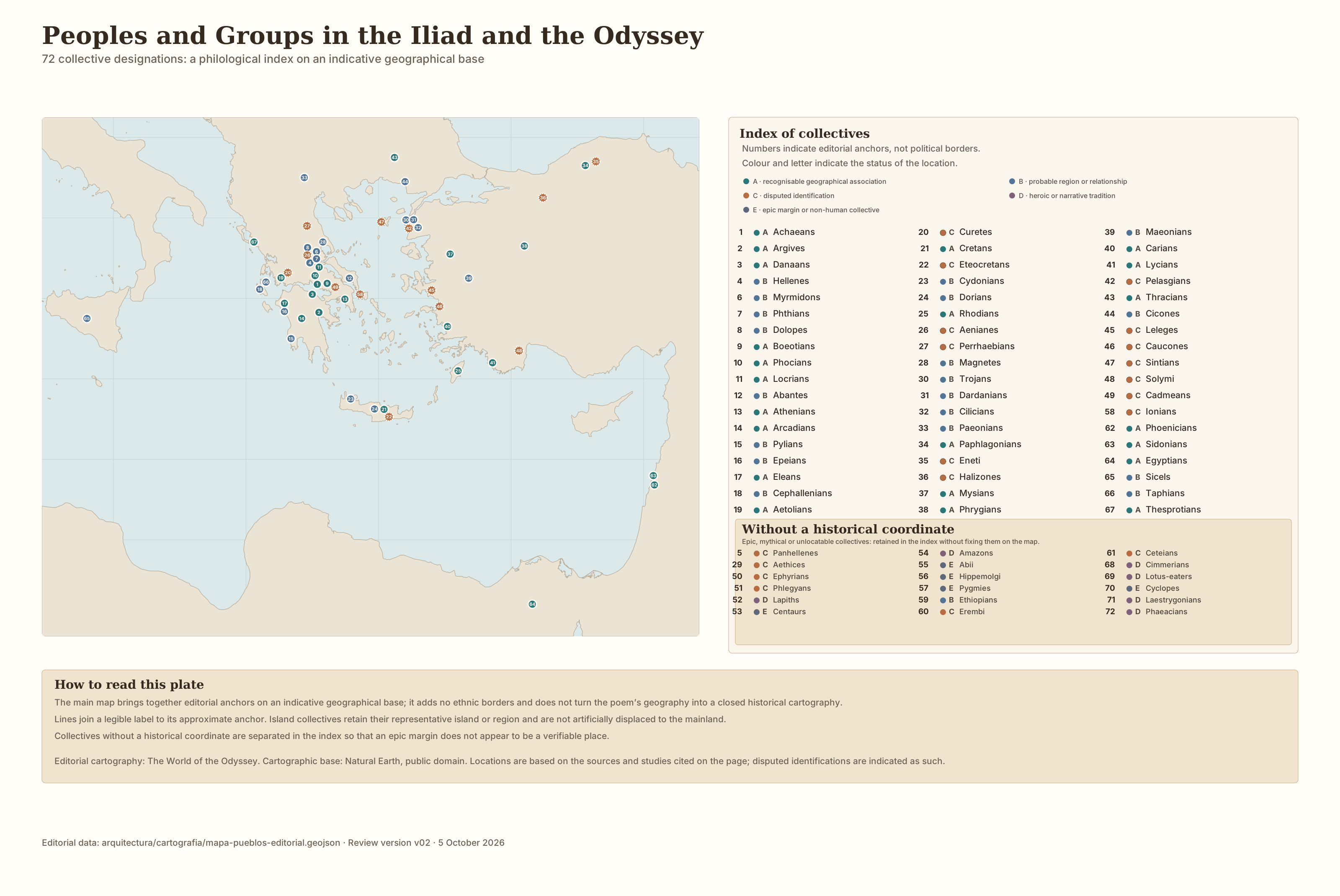
Peoples and Groups in the Iliad and the Odyssey. An indicative diagram of the Homeric human horizon: it brings together areas, names and margins; it does not establish modern ethnic boundaries or reconstruct routes.
How to read this map. The plate offers an overview to accompany the text. It combines historically recognisable peoples, names whose identification is disputed, and epic or liminal communities. The position of a label is intended to orient the reader, not to turn the poem’s geography into exact cartography.
What is counted, and how
Sección titulada «What is counted, and how»The inventory brings together 72 Homeric collective designations: 56 appear in the Iliad, 34 in the Odyssey, and 18 in both poems. Variants used by the poem for the same collective are grouped together, while names whose scope or referent is not equivalent are kept separate.
A group that appears in only one poem retains its own row; an uncertain identification is not forced into correspondence with another.
The table does not treat cities, regions, demonyms and mythical communities as homogeneous historical realities. It records them because the poem names them collectively and then indicates, where relevant, whether their relationship to historical geography is recognisable, cautious, disputed, epic or liminal.
Main results
Sección titulada «Main results»The Iliad: coalition and Catalogue
Sección titulada «The Iliad: coalition and Catalogue»The Catalogue of Ships gathers contingents from Greece, the islands and the Aegean; the Trojan catalogue adds the core of Troy and Dardania together with allies from the Troad, Thrace and Anatolia. The Iliad therefore contains most of the inventory: 56 of the 72 designations.
This accumulation does not amount to a homogeneous territorial administration. It mixes regional contingents, peoples, lineages, archaic names and heroic memories; its value lies in showing the scale of the war, not in providing a diplomatic register.
The Odyssey: travel, contacts and margins
Sección titulada «The Odyssey: travel, contacts and margins»The Odyssey preserves some names connected with the war, but shifts the emphasis towards encounters, stories and travel: Egyptians, Phoenicians and Sidonians; Taphians, Thesprotians and Sicels; and communities such as Cimmerians, Lotus-eaters, Cyclopes, Laestrygonians and Phaeacians. Its 34 designations do not form a complete alternative map, but a horizon of navigation, memory and adventure.
The 18 shared names do not prove that both poems describe the same map or use the same associations. Comparison reveals continuities within the epic tradition as well as differences in narrative function.
Collective names, not nationalities
Sección titulada «Collective names, not nationalities»Achaeans, Argives and Danaans are alternating epic designations for the side fighting against Troy; they are not three stable political or ethnic peoples. ‘Hellenes’, by contrast, has a regional scope in Homer, associated with Phthia. For a fuller discussion, see Were the Achaeans, Argives, Danaans and Hellenes the Same?.
For the same reason, the inventory distinguishes — but does not automatically equate — a people, a region, a city, a demonym, a coalition or a mythical community. The word ‘peoples’ is retained only as the page’s convenient short title.
How to read geography and historicity
Sección titulada «How to read geography and historicity»How much of the world of the Iliad is recognisable?
Sección titulada «How much of the world of the Iliad is recognisable?»Some names can be associated with historical regions or groups with reasonable confidence; others are displaced, disputed in reference, or belong to heroic traditions. Boeotians, Egyptians or Paphlagonians cannot be read in the same way as Amazons, Lapiths and Centaurs; Cyclopes and Laestrygonians belong even more clearly to the extraordinary world of the journey.
The horizon extends beyond the Aegean. To the north and towards Thrace appear Cicones, Thracians, Paeonians and other remote groups; in Anatolia lies the world of Troy’s allies; to the south and towards the Levant appear Ethiopians, Egyptians, Phoenicians and Sidonians. The Greek West and Sicily enter through the Taphians, Thesprotians and Sicels.
At the margins, the poem also names communities whose relationship to historical geography is uncertain, legendary or impossible to fix: the Cimmerians, Lotus-eaters, Cyclopes and Phaeacians. This mixture is part of the scale of the Homeric world, not a flaw in the inventory.
Does this mean Homer had a map of all these peoples?
Sección titulada «Does this mean Homer had a map of all these peoples?»Not necessarily. A person or a culture can know very well how to get from one place to another without arranging all those places in a single image viewed from above. One may know that to reach B one must first pass A; which capes, harbours, islands or mountains serve as landmarks; which region lies beyond another; how long a journey takes; and where travellers, goods or news come from. Knowing routes and relations between places is not the same as locating them all at once on a surface with coordinates, as in a modern atlas.
Pietro Janni, drawing on a term used by Kurt Lewin, employs the concept of hodological space to describe this logic of routes: stages, relative directions, duration and significant points for the traveller. He contrasts it, as an ideal type, with cartographic space, which allows positions and connections to be viewed together on a single surface.
A Homeric example appears when Circe promises to explain to Odysseus ‘the ways and the measures of the journey’ (Odyssey 10.539): the line is significant because it presents travel as a route with stages and measure, not as a grid of coordinates. This does not prove that all Homeric geography works in a single way, nor that the poem depends on a written periplus.
It is therefore useful to distinguish three levels. The Homeric text names places, peoples, routes and durations; Janni’s model is a modern tool for thinking about how such knowledge may be organised; and our Map of Peoples is a modern synoptic construction. By bringing together on one plate Greece and the Aegean, Troy and Anatolia, Thrace, the Levant and Egypt, the Greek West and Sicily, and the epic margins, it allows us to compare data that the poem does not present simultaneously. The map is useful to us, but it should not be projected backwards as the way Homer or his earliest audiences necessarily organised the world.
The table does not flatten these differences. Its Identification status column exists precisely to keep them visible: ‘recognisable’ does not mean that the poem is a modern ethnographic source; ‘epic’ or ‘liminal’ does not mean that the name should disappear from our horizon of reading.
Which peoples are found at the margins?
Sección titulada «Which peoples are found at the margins?»At the margins appear Ethiopians, Cimmerians, Lotus-eaters, Cyclopes, Laestrygonians and Phaeacians, among others. They do not form a homogeneous category: the Ethiopians are a remote people associated in Homer with proximity to the gods; the Cimmerians live by Ocean and darkness; the Cyclopes and Laestrygonians are communities of adventure; the Phaeacians are human, but exceptionally close to the divine world.
Distance allows the narrative to alter the ordinary conditions of human life. It does not require us to assume that all these places lay outside any geographical imagination, but neither does it allow us to fix them as secure points on a map.
Complete reference inventory
Sección titulada «Complete reference inventory»The table preserves all 72 collective designations in the count. The poem columns indicate presence, not frequency or importance; Area or geographical relationship gives an indicative association; and Identification status records the degree of certainty or the narrative character of each case. The inventory is reference material: the main conclusions do not depend on reading every row one by one.
| Collective designation | Iliad | Odyssey | Area or geographical relationship | Identification status |
|---|---|---|---|---|
| Achaeans | ✓ | ✓ | Greece / expedition | Recognisable |
| Argives | ✓ | ✓ | Argos / expedition | Recognisable |
| Danaans | ✓ | ✓ | Greek expedition | Recognisable |
| Hellenes | ✓ | — | Phthia / regional Hellas | With caution |
| Panhellenes | ✓ | — | Achaean collective | Disputed |
| Myrmidons | ✓ | ✓ | Phthia | With caution |
| Phthians | ✓ | — | Phthia | With caution |
| Dolopes | ✓ | — | northern Greece / Phthia | With caution |
| Boeotians | ✓ | — | Boeotia | Recognisable |
| Phocians | ✓ | — | Phocis | Recognisable |
| Locrians | ✓ | — | Locris | Recognisable |
| Abantes | ✓ | — | Euboea | With caution |
| Athenians | ✓ | — | Attica | Recognisable |
| Arcadians | ✓ | — | Arcadia | Recognisable |
| Pylians | ✓ | ✓ | Pylos | With caution |
| Epeians | ✓ | ✓ | Elis | With caution |
| Eleans | ✓ | — | Elis | Recognisable |
| Cephallenians | ✓ | ✓ | Ionian islands | With caution |
| Aetolians | ✓ | — | Aetolia | Recognisable |
| Curetes | ✓ | — | Calydon / Aetolia | Disputed |
| Cretans | ✓ | ✓ | Crete | Recognisable |
| Eteocretans | — | ✓ | Crete | Disputed |
| Cydonians | — | ✓ | western Crete | With caution |
| Dorians | — | ✓ | Crete | With caution |
| Rhodians | ✓ | — | Rhodes | Recognisable |
| Aenianes | ✓ | — | Thessaly / around Dodona | Disputed |
| Perrhaebians | ✓ | — | northern Thessaly / around Dodona | Disputed |
| Magnetes | ✓ | — | Thessaly, Peneus and Pelion | With caution |
| Aethices | ✓ | — | Thessaly, uncertain | Disputed |
| Trojans | ✓ | ✓ | Troad | With caution |
| Dardanians | ✓ | — | Troad / Dardania | With caution |
| Cilicians | ✓ | — | area around Thebe under Placus | With caution |
| Paeonians | ✓ | — | Macedonia / Axios valley | With caution |
| Paphlagonians | ✓ | — | northern Anatolia | Recognisable |
| Eneti | ✓ | — | Paphlagonia / northern Anatolia | Disputed |
| Halizones | ✓ | — | Anatolia, uncertain | Disputed |
| Mysians | ✓ | — | Mysia / north-western Anatolia | Recognisable |
| Phrygians | ✓ | — | Phrygia / central Anatolia | Recognisable |
| Maeonians | ✓ | — | Lydia / Maeonia | With caution |
| Carians | ✓ | — | Caria / south-western Anatolia | Recognisable |
| Lycians | ✓ | — | Lycia / south-western Anatolia | Recognisable |
| Pelasgians | ✓ | ✓ | Troad and Crete | Disputed |
| Thracians | ✓ | — | Thrace / northern Aegean | Recognisable |
| Cicones | ✓ | ✓ | Thracian coast, Ismarus | With caution |
| Leleges | ✓ | — | western Anatolia, uncertain | Disputed |
| Caucones | ✓ | ✓ | western Anatolia, uncertain | Disputed |
| Sintians | ✓ | ✓ | Lemnos | Disputed |
| Solymi | ✓ | ✓ | south-western Anatolia, uncertain | Disputed |
| Cadmeans | ✓ | ✓ | Thebes | Disputed |
| Ephyrians | ✓ | — | Ephyra, uncertain | Disputed |
| Phlegyans | ✓ | — | central Greece, uncertain | Disputed |
| Lapiths | ✓ | ✓ | mythical Thessaly | Epic / legendary |
| Centaurs | ✓ | ✓ | mythical Thessaly | Fabulous / liminal |
| Amazons | ✓ | — | far east / north, uncertain | Epic / legendary |
| Abii | ✓ | — | northern margins, uncertain | Fabulous / liminal |
| Hippemolgi | ✓ | — | northern margins, uncertain | Fabulous / liminal |
| Pygmies | ✓ | — | far south, uncertain | Fabulous / liminal |
| Ionians | ✓ | — | Greece, Homeric referent disputed | Disputed |
| Ethiopians | ✓ | ✓ | south / eastern and western extremes | With caution |
| Erembi | — | ✓ | east or south, uncertain | Disputed |
| Ceteians | — | ✓ | uncertain | Disputed |
| Phoenicians | — | ✓ | Mediterranean Levant | Recognisable |
| Sidonians | — | ✓ | Sidon / Levant | Recognisable |
| Egyptians | — | ✓ | Egypt / Nile | Recognisable |
| Sicels | — | ✓ | Sicily | With caution |
| Taphians | — | ✓ | Ionian islands / Greek West | With caution |
| Thesprotians | — | ✓ | Epirus | Recognisable |
| Cimmerians | — | ✓ | Ocean / unlocatable | Epic / legendary |
| Lotus-eaters | — | ✓ | unlocatable | Epic / legendary |
| Cyclopes | — | ✓ | unlocatable | Fabulous / liminal |
| Laestrygonians | — | ✓ | unlocatable | Legendary / liminal |
| Phaeacians | — | ✓ | Scheria, unlocatable | Epic / legendary |
How to use the inventory. The table presents the complete inventory for reference; it does not turn all the names into equivalent historical peoples. On mobile, the full table can be read horizontally.
Conclusion
Sección titulada «Conclusion»The inventory shows a wide range of collective names, but not a catalogue of comparable nations. The Iliad organises above all a war of coalitions through the Catalogue and its allies; the Odyssey turns part of that repertoire into a horizon of travel, contact and storytelling, and adds remote or extraordinary communities.
Many names can be associated with recognisable geographies; others preserve a traditional memory that is difficult to pin down or belong directly to the mythical world. The result is a narrative map of relations, origins and distances, not a historical cartography with stable borders. That difference is precisely what the inventory is designed to keep visible.
Sources and method
Sección titulada «Sources and method»See also
Sección titulada «See also»- How Far Did Homer’s World Extend?
- Odysseus’ Journey
- Who Fought for Troy?