Part II. The Battlefield
Homer's Armies: I. Organisation · II. The Battlefield · III. Combat
Having examined how Homer's armies were organised, we can now turn to the landscape in which they fought. The Iliad places much of the fighting between the walls of Troy and the Achaean camp, established beside the sea around the ships drawn up on the beach. Between them stretched a plain crossed by rivers and dotted with low rises. This was more than a backdrop: it shaped the movements of the armies, their advances and retreats, and their use of chariots.
A City Above the Plain
Sección titulada «A City Above the Plain»The archaeological site of Hisarlık, identified with ancient Troy, occupies elevated ground overlooking part of the surrounding plain. In the Iliad, the Trojans leave the city through its gates to fight and seek the protection of its walls when they retreat. Homer also mentions the rivers Scamander and Simoeis, as well as the hill of Batieia, geographical references that allow us to recognise certain features of the region (Iliad 2.811–815; 21).
The plain offered open ground for the movement of men and chariots, but we should not imagine it as entirely flat or uniform. Rivers, their banks and marshy areas could hinder movement. Moreover, the landscape described by Homer need not correspond exactly to that of the Bronze Age, several centuries before the poems were composed.
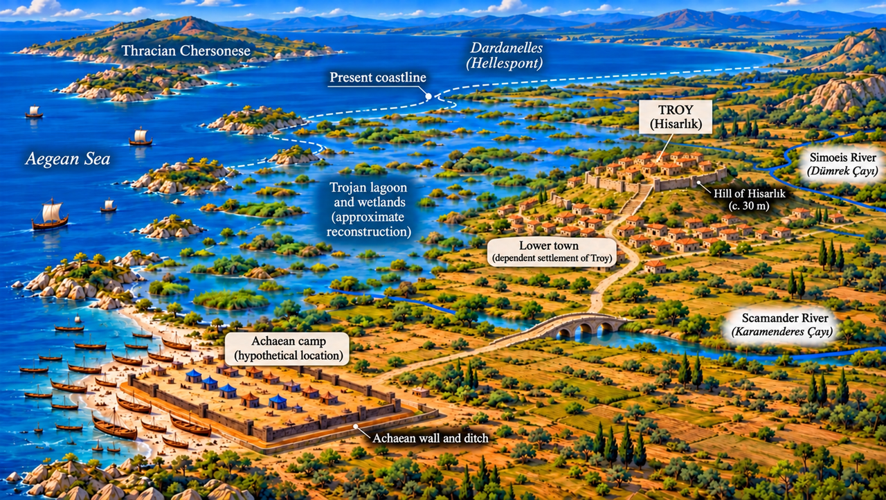
Interpretative reconstruction of the Trojan plain. This illustration was created for El mundo de la Odisea. It is not based on an ancient map and does not claim to reconstruct the battlefield of the Trojan War with precision.
Its reference points include the location of Hisarlık, the identification of the Scamander with the modern Karamenderes and the Simoeis with the Dümrek, and palaeogeographical studies of the changing Trojan plain, including those discussed by Charles Brian Rose in The Archaeology of Greek and Roman Troy (Cambridge University Press, 2014). The extent of the former bay, the wetlands, the courses of the rivers and the position of the Achaean camp are illustrative approximations. The image combines elements of the region's historical geography with a hypothetical representation of the setting described by Homer.
A Coastline That Has Moved
Sección titulada «A Coastline That Has Moved»Geomorphological studies by John C. Kraft, İlhan Kayan and Oğuz Erol show that the landscape around Troy underwent profound changes over the millennia. Sediment carried by the Scamander and Simoeis gradually filled part of the former marine inlet, altering the coastline, the river mouths and the extent of the wetlands. Much of the present-day plain occupies land that was once covered by shallow water or formed part of coastal and alluvial environments.
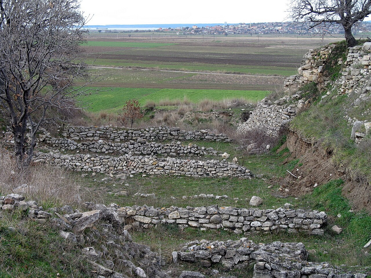
A photograph taken today from the ruins can therefore reveal the breadth of the plain and Hisarlık's elevated position, but not the landscape as it appeared during the Bronze Age. Nor can it establish where the Achaean camp and its ships were located: no site has been securely identified archaeologically as their position.
Did Homer Ever Visit Troy?
Sección titulada «Did Homer Ever Visit Troy?»The geographical references in the Iliad have led some researchers to wonder whether Homer himself ever visited the region of Troy. The poem mentions the rivers Scamander and Simoeis, various elevations on the plain and other places that can be associated with features of the actual landscape.
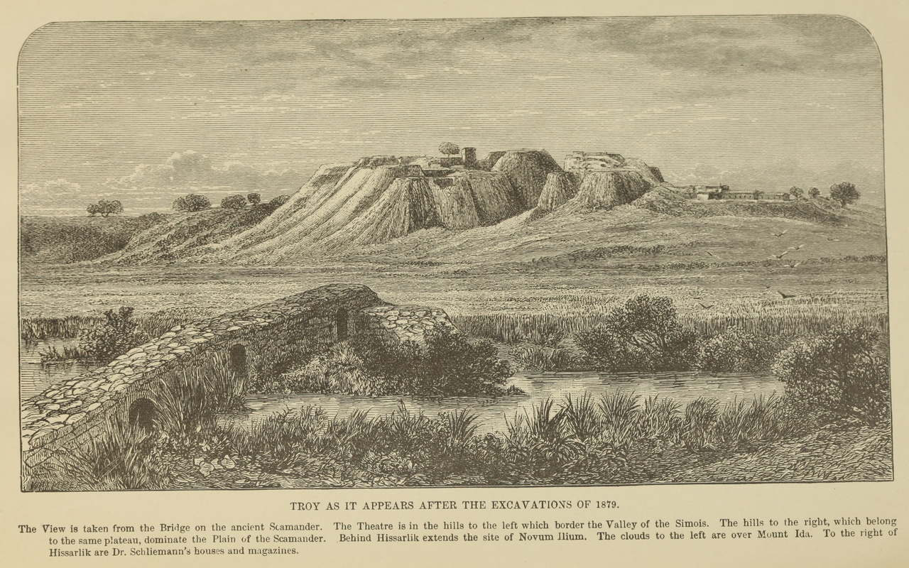
In the nineteenth century, Heinrich Schliemann argued that Homer's knowledge of the Troad's topography and climate suggested that he had visited the region in person. He nevertheless believed that the poet could not have seen the great structures of ancient Troy, which had disappeared long before his time, and that his descriptions of them were drawn from tradition. More than a century later, the geologist John C. Kraft also suggested that the accuracy of certain geographical details might reflect direct observation of the terrain.
The poet could, however, have acquired this knowledge from travellers, local inhabitants or earlier epic traditions. We do not know whether Homer ever visited Troy. The correspondences between the poem and the region's geography suggest familiarity with the landscape, but they cannot establish that this knowledge came from personal experience.
Troy and Its Defences
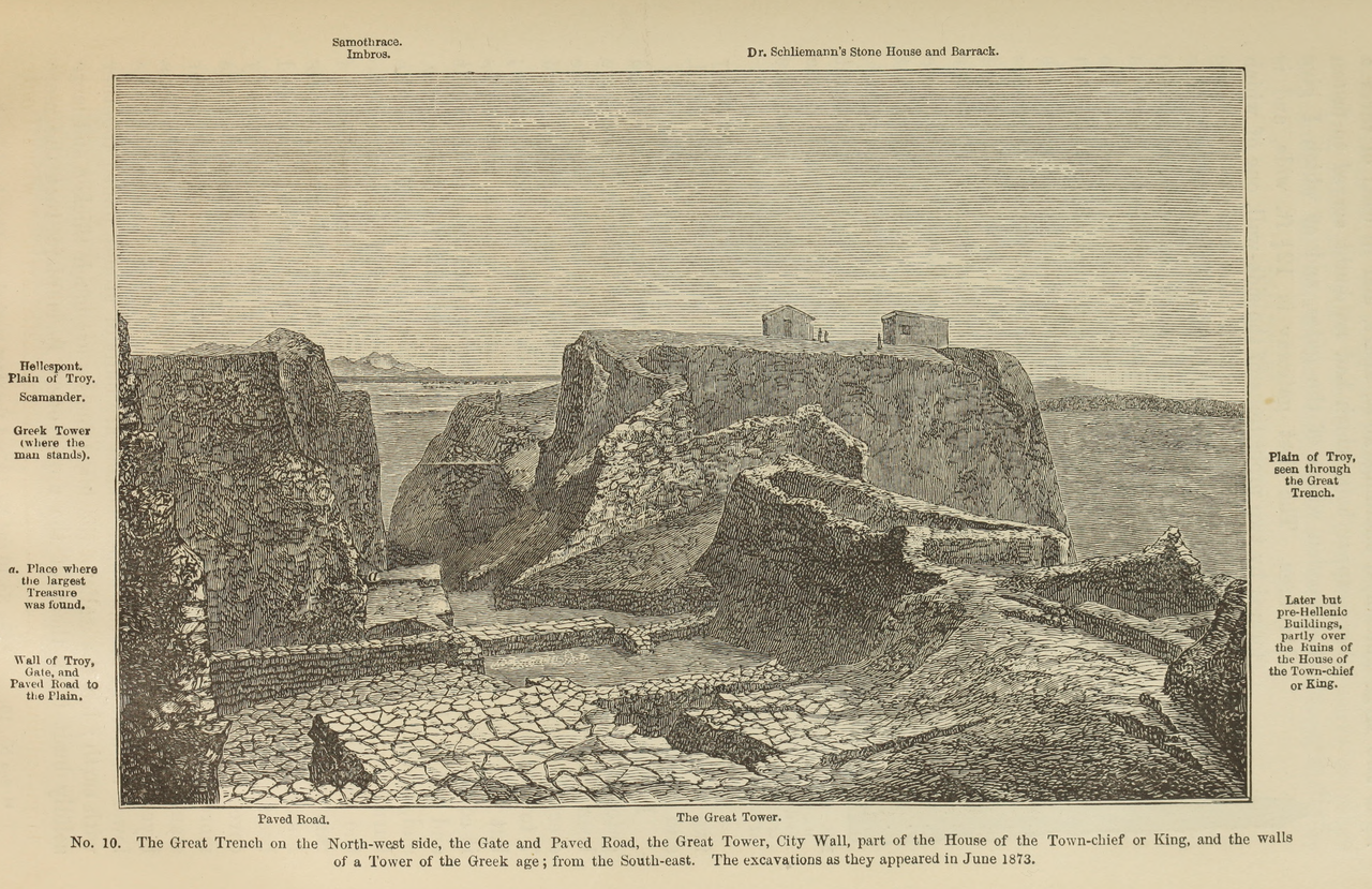
Sección titulada «Troy and Its Defences»The Iliad depicts Troy as a walled city whose gates opened onto the battlefield. Excavations at Hisarlık have shown that the Bronze Age settlement possessed substantial fortifications, although we cannot directly identify the structures uncovered by archaeologists with the places described by Homer.
Archaeologists have identified successive phases of occupation and rebuilding. Among the most significant are Troy VI and Troy VIIa, both dating to the Late Bronze Age and particularly relevant to the historical period commonly associated with the Trojan War.
The fortifications of Troy VI included massive stone walls with sloping outer faces, towers or bastions, and carefully constructed gateways. Some sections still stand several metres high. Mudbrick superstructures once rose above the stone walls, although little of these upper structures survives. These defences show that Troy was a substantial fortified settlement, with entrances connecting the citadel to the surrounding area.
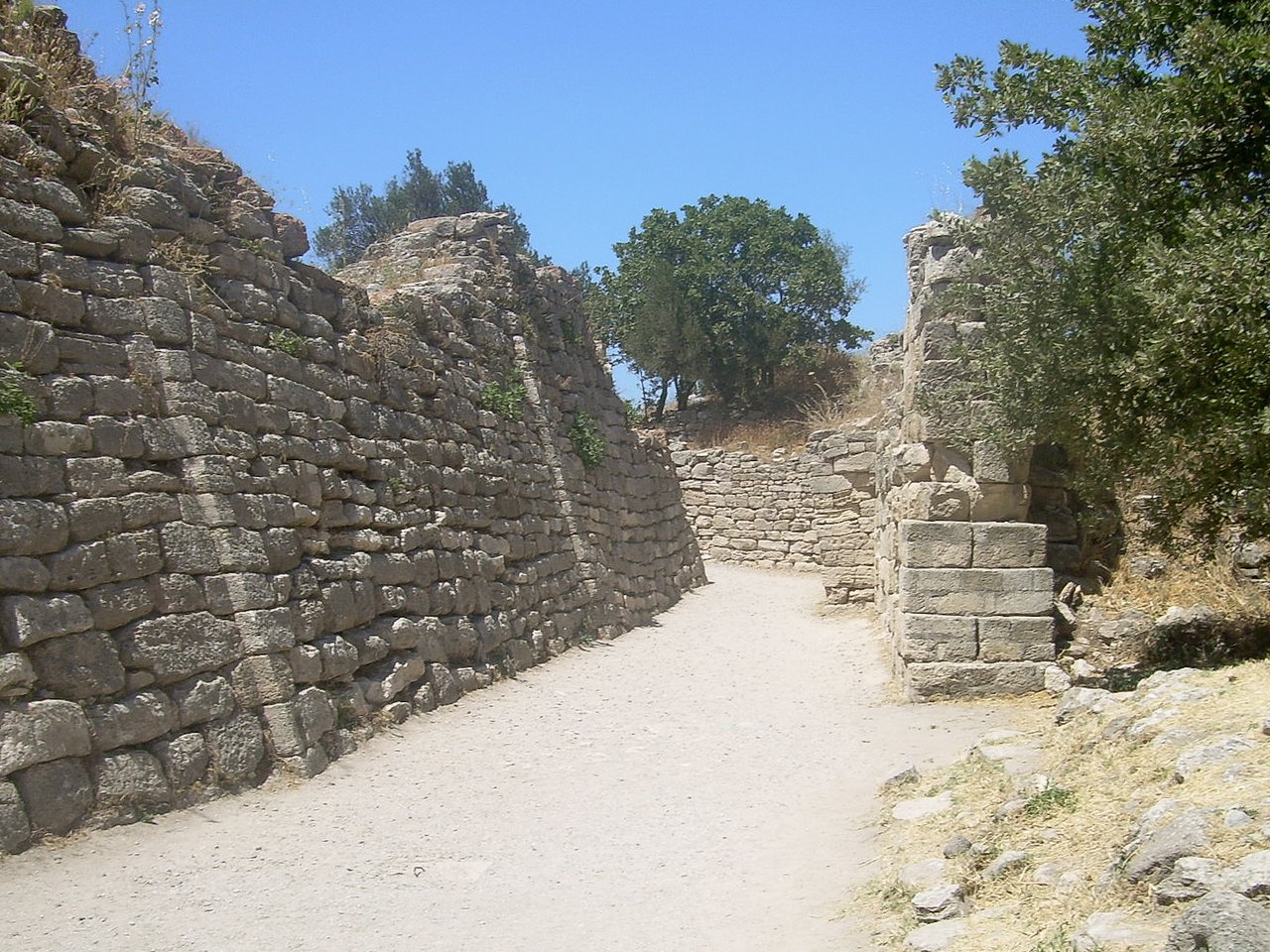
Troy should not be imagined as a fortress confined to the citadel whose walls still stand at Hisarlık. Excavations have also revealed a lower settlement, particularly to the south of the citadel, although its extent and defensive organisation remain subjects of debate.
Sections of ditches cut into the bedrock have been discovered south of Troy VI. Manfred Korfmann and other researchers interpreted them as parts of a defensive system intended to protect the lower town and obstruct the approach of vehicles, including chariots. This interpretation has been challenged, however, and it has not been conclusively demonstrated that the excavated sections formed a continuous defensive enclosure.
In Homer's narrative, Trojan troops leave the city through its gates to fight on the plain and return through them when the battle turns against them. The Scaean Gates feature prominently in these movements. In Book 6, Hector meets Andromache there as he prepares to return to the battlefield (Iliad 6.392–394). Later, Priam orders the gates opened so that the Trojans fleeing Achilles can enter the city (Iliad 21.530–536). In Book 22, Hector remains outside the walls to face his enemy.
Excavations have identified monumental gateways in the fortifications of Troy VI, but none can be securely identified with the Scaean Gates described by Homer.
Priam and the elders of Troy look out over the Achaean army from the city walls as Helen identifies some of its leading commanders (Iliad 3.146–242). This scene, known as the teichoscopy (‘viewing from the walls’), illustrates how the city's elevated position made it possible to survey the plain and recognise those on it. The location of Hisarlık helps us understand this advantage, although we cannot reconstruct the exact view described by Homer.
The Vulnerable Point by the Fig Tree
Sección titulada «The Vulnerable Point by the Fig Tree»One of the most revealing tactical details in the Iliad comes from Andromache's words to Hector. Pleading with him to remain in the city, she advises him to station his men beside a wild fig tree, where the wall is easiest to scale.
Station the army by the wild fig tree, where the city is easiest to scale and the wall most vulnerable to attack.
Andromache explains that the Achaeans have already attempted to attack this section of the wall on three occasions. Among the attackers she names the two Ajaxes, Idomeneus, Agamemnon, Menelaus and Diomedes (Iliad 6.435–439). Her advice is therefore based not only on the terrain but also on experience gained from earlier assaults.
We do not know where the fig tree stood, nor can we associate it with any particular location among the ruins at Hisarlık. Nevertheless, the episode shows that even in a narrative centred on heroic deeds, Homer pays attention to vulnerable points in fortifications and the need to concentrate troops where an attack is likely.
A City That Did Not Fight Only Behind Its Walls
Sección titulada «A City That Did Not Fight Only Behind Its Walls»The Iliad does not describe a continuous siege in which the Trojans remain confined behind their walls. Hector and his allies march out to fight on the plain, advance against the Achaeans and even assault the defences of their camp and attack their ships. The walls of Troy offer refuge when the battle turns against them, but the city is also defended in the open field.
At the opposite end of the plain, the Achaeans had established their own camp. Situated beside the sea to protect the ships and accommodate the warriors, it would eventually be enclosed by a wall and ditch that played a decisive role in the battles described by Homer.
The Achaean Camp and Its Defences
Sección titulada «The Achaean Camp and Its Defences»Beside the sea, the Achaeans established their camp around the ships drawn up on the sand. Homer explains that the vessels were arranged in several rows, one behind another, because the beach, although extensive, did not provide enough space for them all. The ships occupied a broad stretch of coastline between two headlands (Iliad 14.30–36).
The camp consisted of more than ships. The warriors had shelters that Homer calls klisíai (‘huts’ or ‘barracks’), where they rested and kept their possessions. Achilles, for example, receives the envoys sent by Agamemnon in his shelter (Iliad 9.185–221). The poem also describes assemblies, meals, sacrifices and the division of booty, activities that suggest a military community established beside the sea for many years.
We do not know the camp's complete layout and cannot reconstruct the precise arrangement of its shelters and other spaces. Nor has any archaeological site been securely identified as the location of the Achaean ships.
In Book 7 of the Iliad, Nestor proposes building fortifications to protect the camp. The Achaeans construct a wall with towers and gates through which chariots can pass. In front of it, they dig a ditch and set pointed stakes (Iliad 7.336–441).
Homer describes a defensive structure incorporating stone, timber and earth. This is more than a simple palisade: the wall has entrances and raised defensive features, while the ditch presents an obstacle to attackers.
The importance of these defences becomes clear during the Trojan offensive in Book 12. Polydamas warns of the danger of crossing the ditch in chariots and advises Hector to have the warriors continue the attack on foot, leaving their horses in the care of the chariot drivers (Iliad 12.50–107). The fortifications thus force the attackers to change their manner of approach.
One detail deserves attention: these defences are built during the events narrated in the Iliad, when the war is approaching its end. The poem does not explain why the Achaeans had spent so many years without constructing comparable fortifications.
When the Trojans Reached the Ships
Sección titulada «When the Trojans Reached the Ships»The Achaean defences did not prevent the Trojans from entering the camp. During the offensive in Book 12 of the Iliad, Hector lifts an enormous stone and hurls it against one of the gates, smashing its fastenings. The attackers surge through the breached entrance, and fighting continues inside the Achaean positions (Iliad 12.445–471).
The danger reaches its height towards the end of Book 15. Hector advances as far as the ships and manages to set fire to one of them (Iliad 15.704–746). The vessels that had brought the Achaeans to Troy and were meant to carry them home become the last things they have left to defend. Soon afterwards, Patroclus leads the Myrmidons into battle and forces the Trojans to retreat (Iliad 16.1–100; 16.257–291).
The camp was therefore far more than a place of accommodation. Its fortifications protected the ships, and their loss would have threatened both the survival of the expedition and the possibility of returning home.
The Iliad thus presents a battlefield in which Troy's elevated position, the walls of both sides, the rivers and the obstacles posed by the terrain all shaped the course of the fighting. Yet understanding the battlefield is not enough to explain how these men fought. For that, we must examine their weapons, their chariots and the ways in which they confronted their enemies.